2008
Today was the day! I tried last year to paddle the entire length of the
I actually plan to use the same kayak for this trip,
believe it or not. I can’t afford another one amid the
financial mess that I and the rest of the country are in, so I mended it. I first
burned the ends of the cracks so they wouldn’t get worse. I
then put on plastic glue, super glue and, finally, I duct taped (yes, duct
taped!) the cracks from the inside. I’m hoping it’ll hold –
it has to. I’ve tested it a couple times and it’s been OK.
Anyway, as I did last year I plan to navigate this river in circuit routes.
While technically considered a river, the
What I’ll do is go out to a certain point, kayak a circuit and then head back
home. Then, after a day of rest I’ll go back to a point just downriver
from the place where I finished the previous stint and start another circuit –
depending on the weather, of course. I’ll go all the way down the river in this way
in sequence starting with the forks in
Now I know what some may be saying: “Do the whole
river in one continuous trip, you pansy!” That’s fine, but doing it the
way I plan to has some advantages. One, I’ll be able recharge batteries:
my camera, my phone, and my own! Two, I’ll be able to write these journals
while the experience of the previous day is still fresh on my mind. Three,
I won’t have to rely on anyone else to shuttle me around and, finally, I won’t
have to worry about camping out along the way. I don’t mind camping, but
I’ll be going solo (which I can’t recommend, by the way) and that would raise
some safety concerns. I also don’t want to camp on someone’s land who
doesn’t want me there and I don’t want to come upon any booby-trapped drug
caches - I’ve heard that can happen.
On
a lighter note, I experienced what could have been a good omen in regard to this
trip when I read the paper this morning. There was an excellent article
about how
Anyway, after having geared up I headed out and, passing through the
Once in Beattyville I got on the water a little after
My
plan for the next 3 days was to go up each of the 3 forks as far as was
reasonable in one day and then head down the main river after that. On
this day I’d navigate the
Looking across the water (on the right as I got on the
river and headed up) the bank was tree lined and just behind the trees KY52
meandered along with the river for a while. You’ll hear cars going over
the bridge for this road as it crosses the river a little further down, and as
you paddle you’ll begin to cross under several aerial power crossings.
Soon a railroad track will become evident on the left side when the
apartments end.
Brain Creek comes in on the right at mile 1 as per
the Kentucky River Navigation Charts
(upriver mile 1, that is – the miles will count
down once the forks have all converged). The charts I used are a great
resourse to have with you and they're available online at the
Kentucky River
Authority website. Anyway, the Barin Creek was dry today as it entered over a
shoal. On the opposite side was the Beattyville municipal water intake.
There wasn’t much activity here, although you're likely to hear the hum of machinery.
It
was at about this point that I encountered some bugs that I hadn’t seen but a
couple times since moving to the area from
There are 2 little branches that come in on the left
just after mile 2. One of them is Puncheon Branch but I couldn’t really
tell which one. They were both about equal in size – roughly a foot or two
– but certainly not paddle-able.
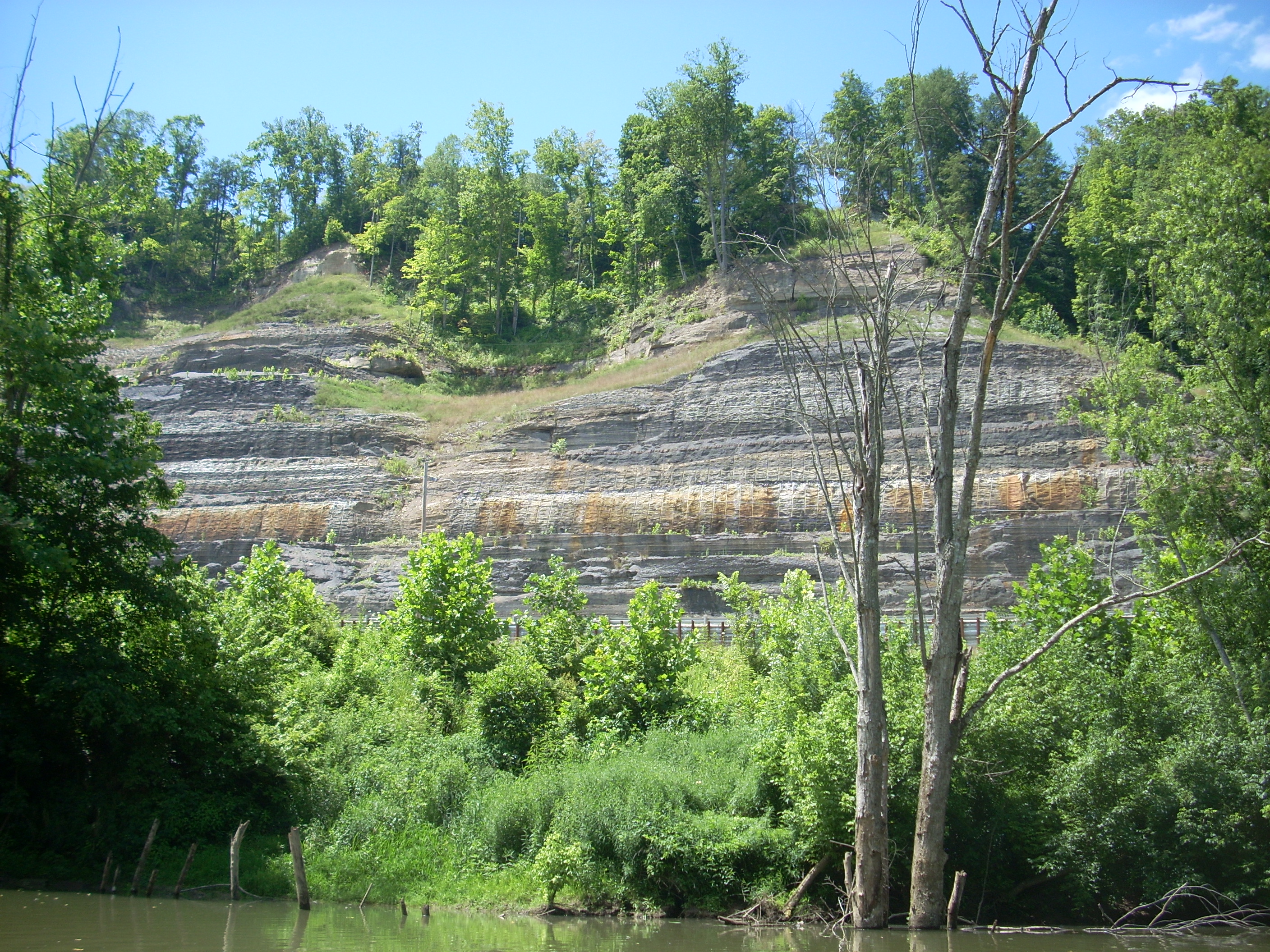
Near mile 3 things got interesting. Just after a boat ramp on the right (not sure if it’s public or not) there’s a large cliff that has been cut through to make room for KY52. It’s a pretty impressive sight.
After this the
river veers sharply to the left, and as it does so it leaves KY52 behind to go
straight under a railroad bridge. This bridge is for the railroad track I
mentioned which has been on
the left ever since the put-in. I
lucked out last year and was able to snap a shot of a train going over it.
After this
point, both road and railroad will be behind you. You’re now left in a more remote
area with farmland on both sides and it’s just before mile 4
that the Middle and North Forks meet. The
When you get to
mile 5.5 the Hell Creek will enter on the left. Unfortunately the
pictures I took last year are unrecoverable (computer crash) so I’m not able to
compare the creek levels as I’d like to, but I don’t recall being able to get into this
creek back then. Today I got in about 20 yards or so before I hit a deadfall. I was, however, able
to check out what appears to have been some old wooden bridge supports.
These form a kind of stair step pattern from one bank of the creek to the other.
The distance isn’t very long – rough guess of 15 yards - but judging from how old
these are they’ve help up pretty well. This must have been a nice little
bridge at one time.
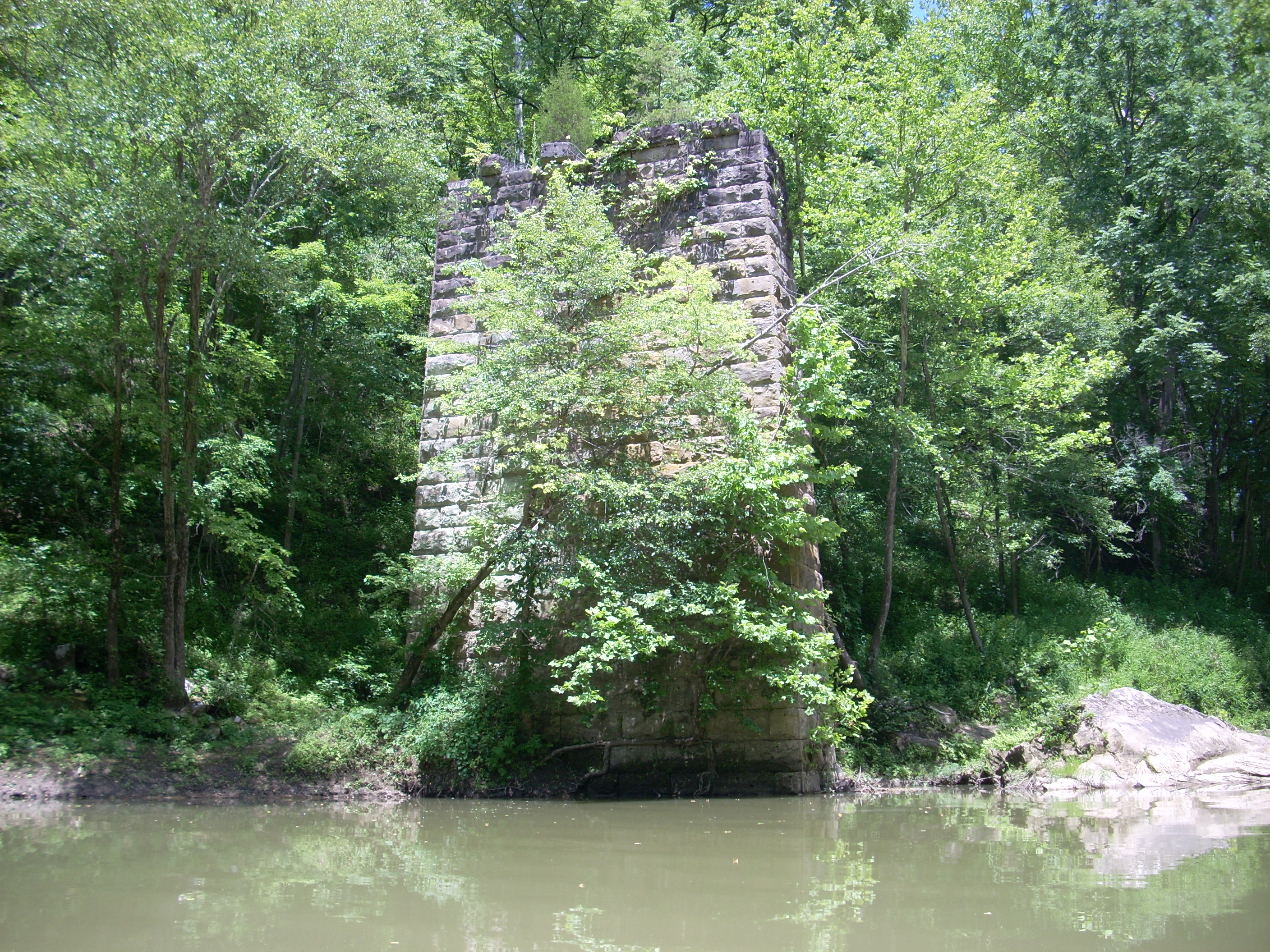
Speaking of old
bridges, there’s a really nice looking stone support for one visible on the
left just after mile 6. This bridge must have been much more substantial
than the one back in Hell Creek though, as it looks to have stretched all the way
across the river. They weren’t as visible this year, but I know that
further back on right bank there are at least 2 more of these columns.
Rounding a curve right, the
Lee County Highway Bridge for Fincastle Road comes into view, and just after you
cross under it the community of Airedale is also partly visible on the left.
Something like Kudzu vines have really taken over on the left bank before the
bridge, and after crossing under it the left bank turns to farmland while a dirt and rock ramp comes down on
the right. I guessed that this was one of the put-in points in the
Canoeing and Kayaking Guide to
The Log Shoal Branch comes in between mile 7 and 8 on the right and the Laurel Branch comes in just after this at about mile 8 on the right. The latter had a large shoal which stretched most of the way across the river, creating some minor rapids on the left. It was at this point that I ended my
It would all be new to me from
here on out. Talk about remote though! I was hoping to paddle at
least until I reached another recognizable landmark or boat ramp but I never did! I must have
gone about 10 miles upriver from the point where I'd left the North/Middle Fork
convergence and I didn’t see another ramp besides the one I had passed back at
Airedale. It was only when I got home and looked at the guide again that I
realized I’d have had to paddle at least another 20 miles before coming to one!
Anyway, I ported over 2 more large
shoals and when I got to a more substantial island-like land mass I finally had
to admit to myself that I needed to get back. The area I stopped in was
really quiet, and there were several large boulders in the water along with some
rocky cliff spots in places. Believe it or not, I actually saw an oil well
through one of the clearings too! Regardless, if you want peace, quiet and
privacy you can most likely find it back here.
There was one creek that came in after one of the shoals on the left that looked large enough to navigate back into, but it was blocked by a multicolored line of what looked something like drainage pipe. There was a little boat back in it. Not a problem though - it didn’t look like I could have gotten very far anyway. It was about
At one point I was startled to see a deer on the bank. It just stood very still and stared at me, although it did run off after I had taken its picture. I thought to myself: “Hey there! No need to run. I’m just passing through!”

At this point I’d like to note a couple more things about bugs. There are 2 kinds that seem to either glide or jump on the water. One looks like a little beetle - just a bit smaller than a ladybug. These seem to glide on the water and when you come up on them they scatter very quickly in myriad directions in a zigzag pattern. The effect is like that of a kaleidoscope - very cool. [6/3/2010 Update - I just found out the name of these! They're called Whirligig Beetles! I discovered this while reading the book: Passages of a Stream - A Chronicle of the Meramac by James P. Jackson. Thank you!]
The second kind appears to be
spider-like and these tiny insects (or arachnids) seem to jump across the water.
When you see them moving around on the surface in the distance the effect is
like that of glitter or sparkle on the water. Say what you will about
bugs, but they sure do some interesting things!
After passing the convergence
of the forks on the way back I began to see my first power boats of the day and
several people fishing onshore soon after that. There were quite a few
vehicles with trailers in the parking lot upon my return to the car as well.
They’d scared off the ducks. I’ll try to see how much of the Middle Fork I
can cover on the next trip.
DIRECTIONS:
At the junction of KY11 and KY52 in Beattyville turn East on